
La Petite Guyonnière topographic map
Interactive map
Click on the map to display elevation.
About this map
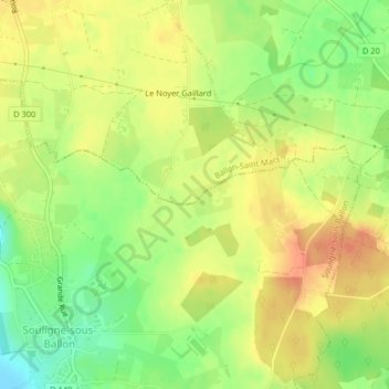
Name: La Petite Guyonnière topographic map, elevation, terrain.
Average elevation: 285 ft
Minimum elevation: 200 ft
Maximum elevation: 351 ft
Other topographic maps
Click on a map to view its topography, its elevation and its terrain.
Le Bois de la Blairie
France > Pays de la Loire > Sarthe > Ballon-Saint Mars
Le Bois de la Blairie, La Grande Blairie, Saint-Mars-sous-Ballon, Ballon-Saint Mars, Le Mans, Sarthe, Pays de la Loire, France métropolitaine, 72290, France
Average elevation: 279 ft
Saint-Mars-sous-Ballon
France > Pays de la Loire > Sarthe > Ballon-Saint Mars
Saint-Mars-sous-Ballon, Ballon-Saint Mars, Le Mans, Sarthe, Pays de la Loire, France métropolitaine, 72290, France
Average elevation: 253 ft