
Make a donation
Gear up for your next adventure:
As an Amazon Associate, this site earns from qualifying purchases at no extra cost to you.
Tubuai topographic map
Click on the map to display elevation.
Make a donation
Gear up for your next adventure:
As an Amazon Associate, this site earns from qualifying purchases at no extra cost to you.
Tubuai
Hours of sunlight is about average for the Australs and is around 1970 hours per year, one of the lowest levels in Polynesia. The humidity is lower in contrast to Tahiti in the order of a few percent, mainly due to its higher latitude and its lower altitude (thus retaining fewer clouds).
Make a donation
Gear up for your next adventure:
As an Amazon Associate, this site earns from qualifying purchases at no extra cost to you.
About this map
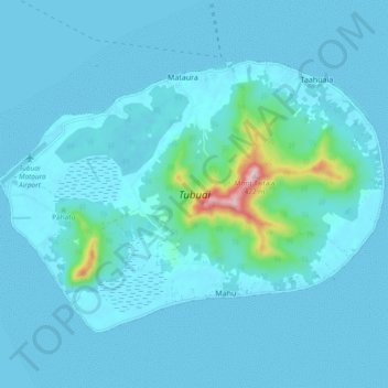
Name: Tubuai topographic map, elevation, terrain.
Location: Tubuai, Austral Islands, French Polynesia, 98754, France (-23.40323 -149.53091 -23.34152 -149.43639)
Average elevation: 98 ft
Minimum elevation: 0 ft
Maximum elevation: 1,339 ft
Make a donation
Gear up for your next adventure:
As an Amazon Associate, this site earns from qualifying purchases at no extra cost to you.
Other topographic maps
Click on a map to view its topography, its elevation and its terrain.
Make a donation
Gear up for your next adventure:
As an Amazon Associate, this site earns from qualifying purchases at no extra cost to you.