
Villingen-Schwenningen topographic map
Interactive map
Click on the map to display elevation.
About this map
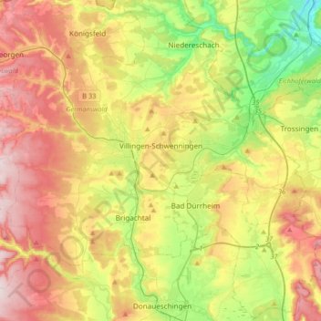
Name: Villingen-Schwenningen topographic map, elevation, terrain.
Average elevation: 2,464 ft
Minimum elevation: 1,827 ft
Maximum elevation: 3,219 ft
Other topographic maps
Click on a map to view its topography, its elevation and its terrain.
Hohe Mark
Duitsland > Baden-Württemberg > Schwarzwald-Baar-Kreis > Villingen-Schwenningen
Hohe Mark, Villingen-Schwenningen, Verwaltungsgemeinschaft Villingen-Schwenningen, Schwarzwald-Baar-Kreis, Baden-Württemberg, 78054, Duitsland
Average elevation: 2,484 ft