
Wahlkreis Toggenburg topographic map
Interactive map
Click on the map to display elevation.
About this map
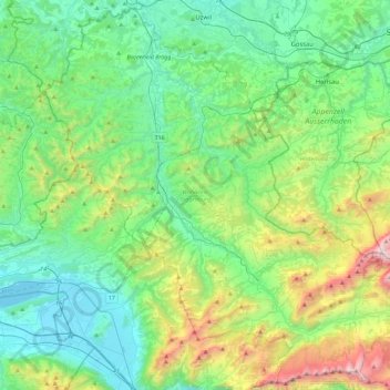
Name: Wahlkreis Toggenburg topographic map, elevation, terrain.
Location: Wahlkreis Toggenburg, St. Gallen, Switzerland (47.14472 8.94352 47.44423 9.40198)
Average elevation: 2,953 ft
Minimum elevation: 1,316 ft
Maximum elevation: 8,133 ft
Other topographic maps
Click on a map to view its topography, its elevation and its terrain.
Alt St. Johann
Switzerland > St. Gallen > Wahlkreis Toggenburg > Wildhaus-Alt St. Johann
Alt St. Johann, Wildhaus-Alt St. Johann, Wahlkreis Toggenburg, St. Gallen, Switzerland
Average elevation: 4,688 ft
Wildhaus-Alt St. Johann
Switzerland > St. Gallen > Wahlkreis Toggenburg
Wildhaus-Alt St. Johann, Wahlkreis Toggenburg, St. Gallen, Switzerland
Average elevation: 4,767 ft