Geolocate

Henderson topographic map

Click on the map to display elevation.

About this map

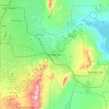
Name: Henderson topographic map, elevation, terrain.

Location: Henderson, Clark County, Nevada, 89009-0625, United States (35.87011 -115.14262 36.19011 -114.82262)

Average elevation: 2,172 ft

Minimum elevation: 1,194 ft

Maximum elevation: 5,046 ft

Clark County trails, hiking, mountain biking, running and outdoor activities

Other topographic maps

Click on a map to view its topography, its elevation and its terrain.

Hillsboro Park

United States > Nevada > Clark County > Henderson

Average elevation: 1,969 ft

Gear up for your next adventure:

🛏️Cold Weather Sleeping Bag - Warm sleeping bag for cold conditions
🏕️Tent Footprint - Protect your tent base from wear
👖Convertible Hiking Pants - Versatile zip-off pants for changing altitudes and temperatures
☀️Outdoor Sunscreen - High protection sunscreen for outdoor activities
🪓Survival Multi‑Tool - Versatile tool for camp and trail tasks

As an Amazon Associate, this site earns from qualifying purchases at no extra cost to you.