
Make a donation
Gear up for your next adventure:
As an Amazon Associate, this site earns from qualifying purchases at no extra cost to you.
Ripatransone topographic map
Click on the map to display elevation.
Make a donation
Gear up for your next adventure:
As an Amazon Associate, this site earns from qualifying purchases at no extra cost to you.
Ripatransone
The climate of Ripatransone is close to the Mediterranean: winters are colder and, although the hilly altitude limits the frequency of snowfalls, they occur more or less annually and can also be intense and lasting. Summers are generally cooler and more airy, with temperatures that are still quite high.
Make a donation
Gear up for your next adventure:
As an Amazon Associate, this site earns from qualifying purchases at no extra cost to you.
About this map
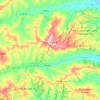
Name: Ripatransone topographic map, elevation, terrain.
Location: Ripatransone, Ascoli Piceno, Marche, 63065, Italy (42.94034 13.68345 43.03569 13.82945)
Average elevation: 646 ft
Minimum elevation: 43 ft
Maximum elevation: 1,624 ft
Make a donation
Gear up for your next adventure:
As an Amazon Associate, this site earns from qualifying purchases at no extra cost to you.
Other topographic maps
Click on a map to view its topography, its elevation and its terrain.
Make a donation
Gear up for your next adventure:
As an Amazon Associate, this site earns from qualifying purchases at no extra cost to you.