
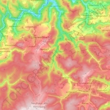
Lichte topographic map
Interactive map
Click on the map to display elevation.
About this map
Name: Lichte topographic map, elevation, terrain.
Average elevation: 2,041 ft
Minimum elevation: 1,050 ft
Maximum elevation: 2,736 ft
Other topographic maps
Click on a map to view its topography, its elevation and its terrain.
Steinheid
Deutschland > Thüringen > Landkreis Sonneberg > Neuhaus am Rennweg
Steinheid, Neuhaus am Rennweg, Landkreis Sonneberg, Thüringen, Deutschland
Average elevation: 2,477 ft
Scheibe-Alsbach
Deutschland > Thüringen > Landkreis Sonneberg > Neuhaus am Rennweg
Scheibe-Alsbach, Neuhaus am Rennweg, Landkreis Sonneberg, Thüringen, Deutschland
Average elevation: 2,428 ft
Siegmundsburg
Deutschland > Thüringen > Landkreis Sonneberg > Neuhaus am Rennweg
Siegmundsburg, Neuhaus am Rennweg, Landkreis Sonneberg, Thüringen, Deutschland
Average elevation: 2,421 ft
Piesau
Deutschland > Thüringen > Landkreis Sonneberg > Neuhaus am Rennweg
Piesau, Neuhaus am Rennweg, Landkreis Sonneberg, Thüringen, Deutschland
Average elevation: 2,385 ft