
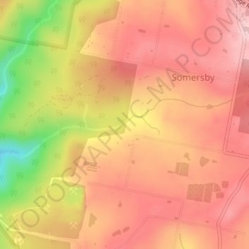
Robinson Creek topographic map
Interactive map
Click on the map to display elevation.
About this map
Name: Robinson Creek topographic map, elevation, terrain.
Average elevation: 751 ft
Minimum elevation: 299 ft
Maximum elevation: 974 ft
Other topographic maps
Click on a map to view its topography, its elevation and its terrain.
Somersby
Australia > New South Wales > Gosford
Somersby, Gosford, Central Coast Council, New South Wales, 2250, Australia
Average elevation: 495 ft
Kariong
Australia > New South Wales > Gosford
Kariong, Gosford, Central Coast Council, New South Wales, 2250, Australia
Average elevation: 282 ft
Narara
Australia > New South Wales > Gosford
Narara, Gosford, Central Coast Council, New South Wales, 2250, Australia
Average elevation: 180 ft
Ettalong Beach
Australia > New South Wales > Gosford
Ettalong Beach, Central Coast Council, New South Wales, 2257, Australia
Average elevation: 30 ft
Umina Beach
Australia > New South Wales > Gosford
Umina Beach, Gosford, Central Coast Council, New South Wales, 2257, Australia
Average elevation: 125 ft
Hawkesbury River
Australia > New South Wales > Gosford > Cowan
Hawkesbury River, Cowan, Gosford, Central Coast Council, New South Wales, 2083, Australia
Average elevation: 269 ft