Geolocate

Eagan topographic map

Click on the map to display elevation.

About this map

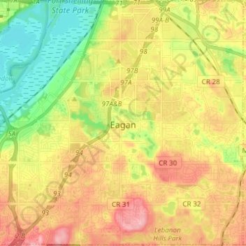
Name: Eagan topographic map, elevation, terrain.

Location: Eagan, Dakota County, Minnesota, United States (44.77563 -93.22787 44.86198 -93.10561)

Average elevation: 876 ft

Minimum elevation: 682 ft

Maximum elevation: 1,076 ft

Dakota County trails, hiking, mountain biking, running and outdoor activities

Other topographic maps

Click on a map to view its topography, its elevation and its terrain.

Pickerel Lake

United States > Minnesota > Dakota County > Lilydale

Average elevation: 827 ft

Hastings

United States > Minnesota > Dakota County

Average elevation: 797 ft

Hastings

United States > Minnesota > Dakota County

Average elevation: 797 ft

Coates

United States > Minnesota > Dakota County > Coates > Coates

Average elevation: 919 ft

Empire Lake

United States > Minnesota > Dakota County

Average elevation: 909 ft

Gear up for your next adventure:

🛰️Satellite Messengers - Emergency SOS and two-way messaging for off-grid adventures
❄️Traction Cleats - Prevent slips on icy trails during winter hikes
🧭Pro Hiking Compasses - High-accuracy liquid-filled compasses for topographic orientation
🗻Climbing Gear Basics - Essential gear for beginner climbers
📶Vehicle Signal Boosters - Improve reception in rural areas while driving to trailheads

As an Amazon Associate, this site earns from qualifying purchases at no extra cost to you.