
Hakendover topographic map
Interactive map
Click on the map to display elevation.
About this map
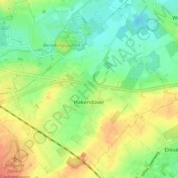
Name: Hakendover topographic map, elevation, terrain.
Location: Hakendover, Tienen, Leuven, Vlaams-Brabant, Vlaanderen, België (50.77837 4.95022 50.81605 5.01274)
Average elevation: 161 ft
Minimum elevation: 92 ft
Maximum elevation: 253 ft
Other topographic maps
Click on a map to view its topography, its elevation and its terrain.
Oorbeek
België > Vlaams-Brabant > Leuven > Tienen
Oorbeek, Tienen, Leuven, Vlaams-Brabant, Vlaanderen, België
Average elevation: 220 ft
Tienen
België > Vlaams-Brabant > Leuven > Tienen
Tienen, Leuven, Vlaams-Brabant, Vlaanderen, 3300, België
Average elevation: 177 ft