
Make a donation
Gear up for your next adventure:
As an Amazon Associate, this site earns from qualifying purchases at no extra cost to you.
Scuol topographic map
Click on the map to display elevation.
Make a donation
Gear up for your next adventure:
As an Amazon Associate, this site earns from qualifying purchases at no extra cost to you.
Scuol
The God da Tamangur ("the forest back there") is the highest continuous stone pine (pinus cembra) forest in Europe, right at the furthest end of the Val S-charl, south of Scuol. The forest nature reserve covers an area of about 84 ha (210 acres) at up to 2,400 m (7,900 ft) in elevation. Due to the altitude and weather, the trees grow very slowly and may live up to 700 years.
Make a donation
Gear up for your next adventure:
As an Amazon Associate, this site earns from qualifying purchases at no extra cost to you.
About this map
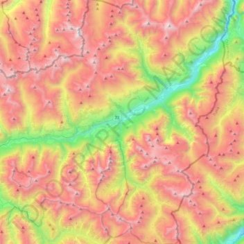
Name: Scuol topographic map, elevation, terrain.
Average elevation: 7,349 ft
Minimum elevation: 3,346 ft
Maximum elevation: 10,991 ft
Make a donation
Gear up for your next adventure:
As an Amazon Associate, this site earns from qualifying purchases at no extra cost to you.
Other topographic maps
Click on a map to view its topography, its elevation and its terrain.
Minschuns
Switzerland > Grisons > Region Engiadina Bassa/Val Müstair > Val Müstair
Average elevation: 7,454 ft
Vulpera
Switzerland > Grisons > Region Engiadina Bassa/Val Müstair > Scuol
Average elevation: 4,921 ft
Make a donation
Gear up for your next adventure:
As an Amazon Associate, this site earns from qualifying purchases at no extra cost to you.
Flüelapass
Switzerland > Grisons > Region Engiadina Bassa/Val Müstair > Zernez
The Flüela Pass (German: Flüelapass, Romansh: Pass dal Flüela, elevation 2,384 m (7,822 ft)) is a high mountain pass of the Swiss Alps in Graubünden. Traditionally considered the boundary between the Albula and Silvretta Alps, the pass crosses the watershed / drainage divide between the basins of the…
Average elevation: 8,425 ft