
Make a donation
Gear up for your next adventure:
As an Amazon Associate, this site earns from qualifying purchases at no extra cost to you.
Cherryville topographic map
Click on the map to display elevation.
Make a donation
Gear up for your next adventure:
As an Amazon Associate, this site earns from qualifying purchases at no extra cost to you.
Cherryville
Cherryville is located in Cherryville Township at an elevation of 1,007 feet (307 m). According to the United States Census Bureau, the city covers a total area of 5.50 square miles (14.25 km2), of which 5.49 square miles (14.22 km2) is land and 0.012 square miles (0.03 km2), or 0.21%, is water. The small Cherryville City Reservoir is located just southeast of the city limits.
Make a donation
Gear up for your next adventure:
As an Amazon Associate, this site earns from qualifying purchases at no extra cost to you.
About this map
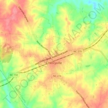
Name: Cherryville topographic map, elevation, terrain.
Average elevation: 909 ft
Minimum elevation: 761 ft
Maximum elevation: 1,030 ft
Gaston County trails, hiking, mountain biking, running and outdoor activities
Make a donation
Gear up for your next adventure:
As an Amazon Associate, this site earns from qualifying purchases at no extra cost to you.
Other topographic maps
Click on a map to view its topography, its elevation and its terrain.
Make a donation
Gear up for your next adventure:
As an Amazon Associate, this site earns from qualifying purchases at no extra cost to you.