
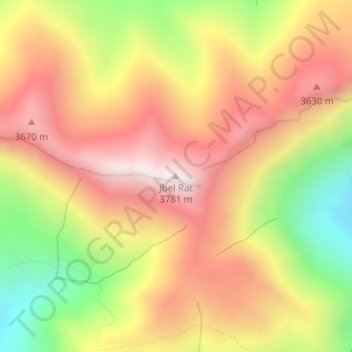
Jbel Rat topographic map
Interactive map
Click on the map to display elevation.
About this map
Name: Jbel Rat topographic map, elevation, terrain.
Average elevation: 11,181 ft
Minimum elevation: 9,626 ft
Maximum elevation: 12,392 ft
Other topographic maps
Click on a map to view its topography, its elevation and its terrain.
Ait Bou Oulli
Maroc > cercle d'Azilal > Aït Bou Oulli
Ait Bou Oulli, Aït Bou Oulli, caïdat de Tabant, cercle d'Azilal, Province d'Azilal, Béni Mellal-Khénifra, Maroc
Average elevation: 6,079 ft
Tarbat n-Tirsal
Maroc > cercle d'Azilal > Aït Bou Oulli
Tarbat n-Tirsal, Aït Bou Oulli, caïdat de Tabant, cercle d'Azilal, Province d'Azilal, Béni Mellal-Khénifra, Maroc
Average elevation: 7,346 ft
Tagassalt
Maroc > cercle d'Azilal > Aït Bou Oulli
Tagassalt, Aït Bou Oulli, caïdat de Tabant, cercle d'Azilal, Province d'Azilal, Béni Mellal-Khénifra, Maroc
Average elevation: 7,392 ft
Jbel Tignousti
Maroc > cercle d'Azilal > Aït Bou Oulli
Jbel Tignousti, Aït Bou Oulli, caïdat de Tabant, cercle d'Azilal, Province d'Azilal, Béni Mellal-Khénifra, Maroc
Average elevation: 11,227 ft
Tarhoulit
Maroc > cercle d'Azilal > Aït Bou Oulli
Tarhoulit, Aït Bou Oulli, caïdat de Tabant, cercle d'Azilal, Province d'Azilal, Béni Mellal-Khénifra, Maroc
Average elevation: 6,306 ft
n'Ait Larif
Maroc > cercle d'Azilal > Aït Bou Oulli > Taghia
n'Ait Larif, Taghia, Aït Bou Oulli, caïdat de Tabant, cercle d'Azilal, Province d'Azilal, Béni Mellal-Khénifra, Maroc
Average elevation: 6,325 ft
Refuge de Tarkeddit
Maroc > cercle d'Azilal > Aït Bou Oulli
Refuge de Tarkeddit, Chemin vers Mgoun, Aït Bou Oulli, caïdat de Tabant, cercle d'Azilal, Province d'Azilal, Béni Mellal-Khénifra, Maroc
Average elevation: 10,036 ft