
Aret topographic map
Interactive map
Click on the map to display elevation.
About this map
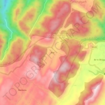
Name: Aret topographic map, elevation, terrain.
Average elevation: 3,166 ft
Minimum elevation: 2,037 ft
Maximum elevation: 3,757 ft
Other topographic maps
Click on a map to view its topography, its elevation and its terrain.
Kumbhalgarh Fort
India > Rajasthan > Kumbhalgarh Tehsil > Quila Kumbhalgarh > Aret
Kumbhalgarh Fort, SH49, Aret, Quila Kumbhalgarh, Kumbhalgarh Tehsil, Rajsamand District, Rajasthan, India
Average elevation: 2,874 ft