
Parque Natural de Corralejo topographic map
Interactive map
Click on the map to display elevation.
About this map
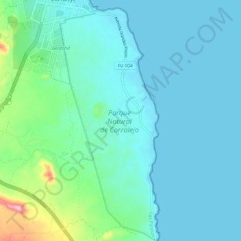
Name: Parque Natural de Corralejo topographic map, elevation, terrain.
Average elevation: 112 ft
Minimum elevation: -10 ft
Maximum elevation: 735 ft
Other topographic maps
Click on a map to view its topography, its elevation and its terrain.
Malpais de la Arena
Malpais de la Arena, Calle Montaña de la Arena, Villaverde, La Oliva, Las Palmas, Canarias, 35650, España
Average elevation: 715 ft