
Ostuni topographic map
Interactive map
Click on the map to display elevation.
About this map
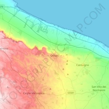
Name: Ostuni topographic map, elevation, terrain.
Location: Ostuni, Brindisi, Apulien, 72017, Italien (40.64153 17.36467 40.81790 17.67662)
Average elevation: 433 ft
Minimum elevation: -10 ft
Maximum elevation: 1,302 ft
Ostuni liegt etwa acht Kilometer landeinwärts von der Küste der Adria. Der Ortskern liegt auf drei Hügeln mit Blick auf die Olivenhaine vor der Adriaküste auf einer durchschnittlichen Höhe von 223 Metern.