
Balili topographic map
Click on the map to display elevation.
About this map
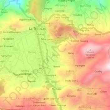
Name: Balili topographic map, elevation, terrain.
Average elevation: 4,557 ft
Minimum elevation: 3,274 ft
Maximum elevation: 5,541 ft
Other topographic maps
Click on a map to view its topography, its elevation and its terrain.
Ambuklao Dam
Philippines > Benguet > Ambuclao > Ambangol
SNAP-Benguet began a massive rehabilitation project that restored Ambuklao to operating status and increased its capacity from 75 MW to 105 MW. The project required the construction of a new intake, headrace and penstock, elevation of tailrace tunnel outlet, de-silting of tailrace tunnel and replacement of…
Average elevation: 2,651 ft
Waiting shed at the OPAg building, Wangal
Philippines > Benguet > La Trinidad > Upper Wangal
Average elevation: 4,436 ft