
Lindlar topographic map
Interactive map
Click on the map to display elevation.
About this map
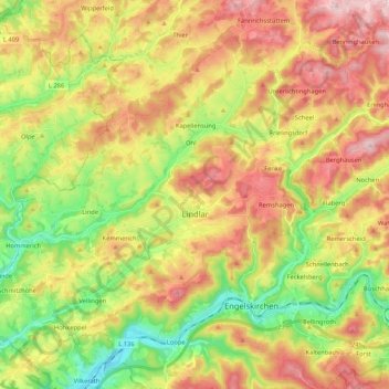
Name: Lindlar topographic map, elevation, terrain.
Average elevation: 801 ft
Minimum elevation: 328 ft
Maximum elevation: 1,322 ft
Lindlar liegt zwischen 7° 15' und 7° 28' östlicher Länge sowie 50° 58' und 51° 5' nördlicher Breite. Der höchste Punkt von Lindlar mit einer Höhe von 376,3 Metern liegt bei Oberlichtinghagen, der tiefste mit 110 m bei Oberbilstein.
Other topographic maps
Click on a map to view its topography, its elevation and its terrain.
Frielingsdorf
Deutschland > Nordrhein-Westfalen > Lindlar > Frielingsdorf
Frielingsdorf, Lindlar, Oberbergischer Kreis, Nordrhein-Westfalen, 51789, Deutschland
Average elevation: 899 ft