
Lido di Ostia topographic map
Interactive map
Click on the map to display elevation.
About this map
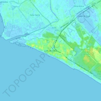
Name: Lido di Ostia topographic map, elevation, terrain.
Location: Lido di Ostia, Rome, Roma Capitale, Latium, 00121, Italie (41.69260 12.23846 41.77260 12.31846)
Average elevation: 7 ft
Minimum elevation: -13 ft
Maximum elevation: 49 ft
Other topographic maps
Click on a map to view its topography, its elevation and its terrain.
Monte Mario
Italie > Latium > Roma Capitale > Rome
Monte Mario, Rome, Roma Capitale, Latium, 00136, Italie
Average elevation: 213 ft
Pincio
Italie > Latium > Roma Capitale > Rome
Pincio, Municipio Roma I, Rome, Roma Capitale, Latium, Italie
Average elevation: 151 ft
La Castelluccia
Italie > Latium > Roma Capitale > Rome
La Castelluccia, Municipio Roma XIV, Rome, Roma Capitale, Latium, Italie
Average elevation: 423 ft