
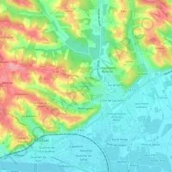
Le Fraisse topographic map
Interactive map
Click on the map to display elevation.
About this map
Name: Le Fraisse topographic map, elevation, terrain.
Average elevation: 358 ft
Minimum elevation: 213 ft
Maximum elevation: 607 ft
Other topographic maps
Click on a map to view its topography, its elevation and its terrain.
Borde Rouge
France > Occitanie > Tarn-et-Garonne > Moissac
Borde Rouge, Moissac, Castelsarrasin, Tarn-et-Garonne, Occitanie, France métropolitaine, 82200, France
Average elevation: 276 ft
Mathaly
France > Occitanie > Tarn-et-Garonne > Moissac
Mathaly, Moissac, Castelsarrasin, Tarn-et-Garonne, Occitanie, France métropolitaine, 82200, France
Average elevation: 466 ft
Rouzet
France > Occitanie > Tarn-et-Garonne > Moissac
Rouzet, Moissac, Castelsarrasin, Tarn-et-Garonne, Occitanie, France métropolitaine, 82200, France
Average elevation: 259 ft
La Tour
France > Occitanie > Tarn-et-Garonne > Moissac
La Tour, Moissac, Castelsarrasin, Tarn-et-Garonne, Occitanie, France métropolitaine, 82200, France
Average elevation: 276 ft
Beline
France > Occitanie > Tarn-et-Garonne > Moissac
Beline, Moissac, Castelsarrasin, Tarn-et-Garonne, Occitanie, France métropolitaine, 82200, France
Average elevation: 295 ft