
เกาะช้าง topographic map
Interactive map
Click on the map to display elevation.
About this map
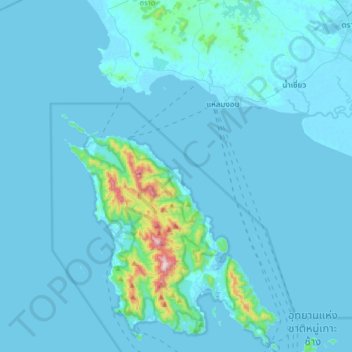
Name: เกาะช้าง topographic map, elevation, terrain.
Location: เกาะช้าง, Trat, Thailand (11.94664 102.19078 12.26664 102.51078)
Average elevation: 121 ft
Minimum elevation: -7 ft
Maximum elevation: 2,359 ft
Other topographic maps
Click on a map to view its topography, its elevation and its terrain.