
Cattenom topographic map
Interactive map
Click on the map to display elevation.
About this map
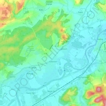
Name: Cattenom topographic map, elevation, terrain.
Average elevation: 564 ft
Minimum elevation: 469 ft
Maximum elevation: 915 ft
Other topographic maps
Click on a map to view its topography, its elevation and its terrain.
Galgenberg
Frankrijk > Grand Est > Cattenom
Galgenberg, Cattenom, Thionville, Moselle, Grand Est, Metropolitaans Frankrijk, 57570, Frankrijk
Average elevation: 564 ft