
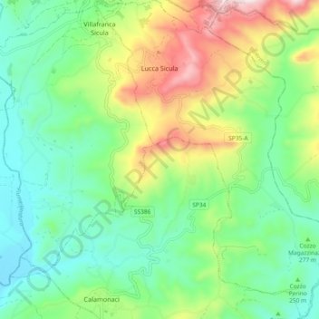
Lucca Sicula topographic map
Interactive map
Click on the map to display elevation.
About this map
Name: Lucca Sicula topographic map, elevation, terrain.
Location: Lucca Sicula, Agrigento, Sicily, 92010, Italy (37.52159 13.28816 37.59460 13.35630)
Average elevation: 945 ft
Minimum elevation: 279 ft
Maximum elevation: 2,336 ft
Other topographic maps
Click on a map to view its topography, its elevation and its terrain.