
Lozzi topographic map
Interactive map
Click on the map to display elevation.
About this map
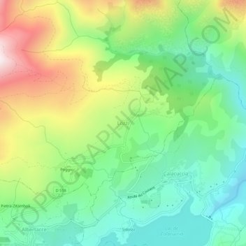
Name: Lozzi topographic map, elevation, terrain.
Average elevation: 3,356 ft
Minimum elevation: 2,313 ft
Maximum elevation: 5,190 ft
Das Gemeindegebiet liegt zwischen 817 und 2710 m über Meer; damit ist Lozzi die höchstgelegene Gemeinde Korsikas. Außerdem zählt der Gipfel des höchsten Berges Korsikas, der Monte Cintu (sprich: Tchinn-Tou), mit 2710 m Höhe zur Gemeinde. Im Gemeindegebiet entspringt auch auf 2300 m Höhe der Fluss Ercu, und zwar aus dem See Lac du Cinto.