
Saint-Gabriel-de-Brandon topographic map
Interactive map
Click on the map to display elevation.
About this map
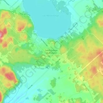
Name: Saint-Gabriel-de-Brandon topographic map, elevation, terrain.
Average elevation: 614 ft
Minimum elevation: 430 ft
Maximum elevation: 1,053 ft
Other topographic maps
Click on a map to view its topography, its elevation and its terrain.
Lac Maskinongé
Canada > Québec > D'Autray > Saint-Gabriel > Saint-Gabriel-de-Brandon
Lac Maskinongé, Saint-Gabriel-de-Brandon, Saint-Gabriel, D'Autray, Lanaudière, Québec, Canada
Average elevation: 486 ft