
Make a donation
Gear up for your next adventure:
As an Amazon Associate, this site earns from qualifying purchases at no extra cost to you.
Oñati topographic map
Click on the map to display elevation.
Make a donation
Gear up for your next adventure:
As an Amazon Associate, this site earns from qualifying purchases at no extra cost to you.
About this map
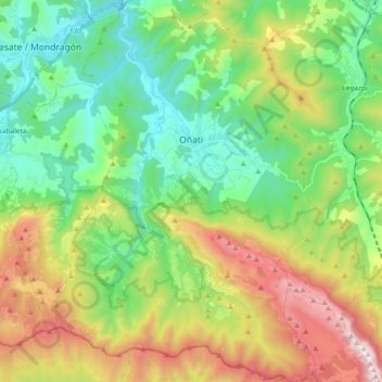
Name: Oñati topographic map, elevation, terrain.
Average elevation: 2,087 ft
Minimum elevation: 577 ft
Maximum elevation: 4,993 ft
Make a donation
Gear up for your next adventure:
As an Amazon Associate, this site earns from qualifying purchases at no extra cost to you.
Other topographic maps
Click on a map to view its topography, its elevation and its terrain.
Hondarribiko hondartza
Spain > Autonomous Community of the Basque Country > Gipuzkoako Bidasoa > Hondarribia
Average elevation: 102 ft
Marabi
Spain > Autonomous Community of the Basque Country > Amorebieta-Etxano
Average elevation: 528 ft
Make a donation
Gear up for your next adventure:
As an Amazon Associate, this site earns from qualifying purchases at no extra cost to you.
Karakate
Spain > Autonomous Community of the Basque Country > Debabarrena > Soraluze
Average elevation: 1,201 ft
Gebara
Spain > Autonomous Community of the Basque Country > Arabako lautada/Llanada Alavesa
Average elevation: 1,883 ft
Larraitz
Spain > Autonomous Community of the Basque Country > Abaltzisketa
Average elevation: 1,565 ft
Make a donation
Gear up for your next adventure:
As an Amazon Associate, this site earns from qualifying purchases at no extra cost to you.
Soil
Spain > Autonomous Community of the Basque Country > Arabako Mendialdea
Average elevation: 2,946 ft
Makola
Spain > Autonomous Community of the Basque Country > Urola-Kosta > Azkoitia
Average elevation: 1,690 ft
Gorbeia
Spain > Autonomous Community of the Basque Country > Gorbeialdea > Zeanuri
Average elevation: 3,901 ft
Make a donation
Gear up for your next adventure:
As an Amazon Associate, this site earns from qualifying purchases at no extra cost to you.
Santa Barbara
Spain > Autonomous Community of the Basque Country > Hernani > Sorgintxulo
Average elevation: 223 ft
Bujal
Spain > Autonomous Community of the Basque Country > Añanako kuadrilla > Berantevilla
Average elevation: 1,755 ft
Araneta
Spain > Autonomous Community of the Basque Country > Gasteizko kuadrilla/Cuadrilla de Vitoria > Vitoria-Gasteiz > Bolívar
Average elevation: 2,051 ft
Make a donation
Gear up for your next adventure:
As an Amazon Associate, this site earns from qualifying purchases at no extra cost to you.
Soil
Spain > Autonomous Community of the Basque Country > Montaña Alavesa/Arabako Mendialdea
Average elevation: 2,946 ft
Fuente Oneri
Spain > Autonomous Community of the Basque Country > Arabako lautada/Llanada Alavesa > Agurain/Salvatierra
Average elevation: 2,234 ft
Iruka
Spain > Autonomous Community of the Basque Country > Debabarrena > Eibar
Average elevation: 1,394 ft
Make a donation
Gear up for your next adventure:
As an Amazon Associate, this site earns from qualifying purchases at no extra cost to you.
Torrea
Spain > Autonomous Community of the Basque Country > Debabarrena > Eibar
Average elevation: 1,306 ft
Flysch
Spain > Autonomous Community of the Basque Country > Urola-Kosta > Zumaia
Average elevation: 89 ft
Barinatxe - La Salvaje
Spain > Autonomous Community of the Basque Country > Sopela
Average elevation: 85 ft
Lore-Toki
Spain > Autonomous Community of the Basque Country > Arabako Errioxa/Rioja Alavesa > Labastida/Bastida
Average elevation: 1,637 ft
Make a donation
Gear up for your next adventure:
As an Amazon Associate, this site earns from qualifying purchases at no extra cost to you.
Trevilla
Spain > Autonomous Community of the Basque Country > Karrantza Harana/Valle de Carranza > Concha
Average elevation: 1,093 ft
Make a donation
Gear up for your next adventure:
As an Amazon Associate, this site earns from qualifying purchases at no extra cost to you.
Floreaga
Spain > Autonomous Community of the Basque Country > Urola-Kosta > Azkoitia
Average elevation: 873 ft
Monterredondo
Spain > Autonomous Community of the Basque Country > Añanako kuadrilla/Cuadrilla de Añana
Average elevation: 2,871 ft
Make a donation
Gear up for your next adventure:
As an Amazon Associate, this site earns from qualifying purchases at no extra cost to you.
Oñati
Spain > Autonomous Community of the Basque Country > Debagoiena > Oñati
Average elevation: 1,601 ft
Plaza de Larrazábal
Spain > Autonomous Community of the Basque Country > Bilbao
Average elevation: 331 ft
Make a donation
Gear up for your next adventure:
As an Amazon Associate, this site earns from qualifying purchases at no extra cost to you.
Gautegiz Arteaga
Spain > Autonomous Community of the Basque Country > Gautegiz Arteaga > Gautegiz Arteaga
Average elevation: 341 ft
Zaldibar
Spain > Autonomous Community of the Basque Country > Zaldibar > Zaldibar
Average elevation: 1,001 ft
Soil
Spain > Autonomous Community of the Basque Country > Montaña Alavesa/Arabako Mendialdea
Average elevation: 2,946 ft