
logan hubble park topographic map
Interactive map
Click on the map to display elevation.
About this map
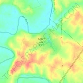
Name: logan hubble park topographic map, elevation, terrain.
Location: logan hubble park, Lincoln County, Kentucky, United States (37.58172 -84.62956 37.59058 -84.61389)
Average elevation: 876 ft
Minimum elevation: 787 ft
Maximum elevation: 978 ft
Other topographic maps
Click on a map to view its topography, its elevation and its terrain.
Hustonville
United States > Kentucky > Lincoln County
Hustonville, Lincoln County, Kentucky, United States
Average elevation: 1,037 ft
Stanford
United States > Kentucky > Lincoln County
Stanford, Lincoln County, Kentucky, United States
Average elevation: 958 ft
Kings Mountain
United States > Kentucky > Lincoln County
Kings Mountain, Lincoln County, Kentucky, 40442, United States
Average elevation: 1,230 ft
Blue Lick
United States > Kentucky > Lincoln County
Blue Lick, Lincoln County, Kentucky, 40484, United States
Average elevation: 1,102 ft
Crab Orchard
United States > Kentucky > Lincoln County
Crab Orchard, Lincoln County, Kentucky, United States
Average elevation: 928 ft