
Rasht topographic map
Interactive map
Click on the map to display elevation.
About this map
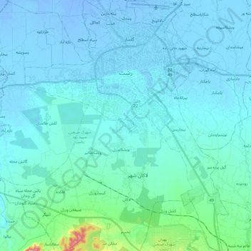
Name: Rasht topographic map, elevation, terrain.
Average elevation: 33 ft
Minimum elevation: -69 ft
Maximum elevation: 466 ft
Other topographic maps
Click on a map to view its topography, its elevation and its terrain.
دهستان اسلام آباد
Iran > Gilan Province > Rasht County
دهستان اسلام آباد, بخش سنگر, Rasht County, Gilan Province, Iran
Average elevation: 210 ft
Sangar
Iran > Gilan Province > Rasht County > دهستان اسلام آباد
Sangar, دهستان اسلام آباد, بخش سنگر, Rasht County, Gilan Province, Iran
Average elevation: 95 ft