
Laboissière topographic map
Interactive map
Click on the map to display elevation.
About this map
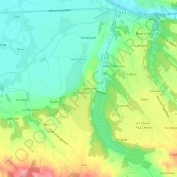
Name: Laboissière topographic map, elevation, terrain.
Average elevation: 440 ft
Minimum elevation: 305 ft
Maximum elevation: 669 ft
Other topographic maps
Click on a map to view its topography, its elevation and its terrain.
Revel
France > Occitanie > Tarn-et-Garonne > Vaïssac
Revel, Vaïssac, Montauban, Tarn-et-Garonne, Occitanie, France métropolitaine, 82800, France
Average elevation: 469 ft
Malraynal
France > Occitanie > Tarn-et-Garonne > Vaïssac
Malraynal, Vaïssac, Montauban, Tarn-et-Garonne, Occitanie, France métropolitaine, 82800, France
Average elevation: 561 ft