
Hayfield topographic map
Interactive map
Click on the map to display elevation.
About this map
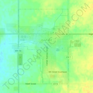
Name: Hayfield topographic map, elevation, terrain.
Location: Hayfield, Dodge County, Minnesota, United States (43.87787 -92.85925 43.89957 -92.83408)
Average elevation: 1,325 ft
Minimum elevation: 1,286 ft
Maximum elevation: 1,362 ft
Other topographic maps
Click on a map to view its topography, its elevation and its terrain.
Dodge Center
United States > Minnesota > Dodge County
Dodge Center, Dodge County, Minnesota, United States
Average elevation: 1,270 ft
West Concord
United States > Minnesota > Dodge County
West Concord, Dodge County, Minnesota, United States
Average elevation: 1,234 ft
Kasson
United States > Minnesota > Dodge County
Kasson, Dodge County, Minnesota, United States
Average elevation: 1,243 ft
Wasioja
United States > Minnesota > Dodge County
Wasioja, Dodge County, Minnesota, United States
Average elevation: 1,207 ft
Claremont
United States > Minnesota > Dodge County
Claremont, Dodge County, Minnesota, United States
Average elevation: 1,276 ft
Mantorville
United States > Minnesota > Dodge County
Mantorville, Dodge County, Minnesota, 55955, United States
Average elevation: 1,181 ft