
Gorfolí topographic map
Interactive map
Click on the map to display elevation.
About this map
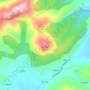
Name: Gorfolí topographic map, elevation, terrain.
Location: Gorfolí, Llanera, Asturias, 33411, España (43.48095 -5.93137 43.48105 -5.93127)
Average elevation: 1,132 ft
Minimum elevation: 692 ft
Maximum elevation: 1,991 ft
Other topographic maps
Click on a map to view its topography, its elevation and its terrain.
Santolaya / Soto de Llanera
España > Asturias > Llanera > Santolaya / Soto de Llanera
Santolaya / Soto de Llanera, Llanera, Asturias, 33423, España
Average elevation: 666 ft
Posada de Llanera
Posada de Llanera, Llanera, Asturias, 33424, España
Average elevation: 679 ft
Prubia
España > Asturias > Llanera > Santolaya / Soto de Llanera > Prubia de Abajo
Prubia, Prubia de Abajo, Santolaya / Soto de Llanera, Llanera, Asturias, 33423, España
Average elevation: 650 ft