
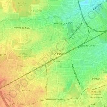
Le Bourg topographic map
Interactive map
Click on the map to display elevation.
About this map
Name: Le Bourg topographic map, elevation, terrain.
Average elevation: 112 ft
Minimum elevation: 36 ft
Maximum elevation: 164 ft
Other topographic maps
Click on a map to view its topography, its elevation and its terrain.
Noès
France > Nouvelle-Aquitaine > Pessac
Noès, Pessac, Bordeaux, Gironde, Nouvelle-Aquitaine, France métropolitaine, 33600, France
Average elevation: 118 ft
Arago-La Chataigneraie
France > Nouvelle-Aquitaine > Pessac
Arago-La Chataigneraie, Pessac, Bordeaux, Gironde, Nouvelle-Aquitaine, France métropolitaine, 33600, France
Average elevation: 151 ft
Brivazac-Candau
France > Nouvelle-Aquitaine > Pessac
Brivazac-Candau, Pessac, Bordeaux, Gironde, Nouvelle-Aquitaine, France métropolitaine, 33600, France
Average elevation: 89 ft
Saige
France > Nouvelle-Aquitaine > Pessac
Saige, Pessac, Bordeaux, Gironde, Nouvelle-Aquitaine, France métropolitaine, 33600, France
Average elevation: 135 ft