Aix-en-Provence topographic map
Interactive map
Click on the map to display elevation.
About this map
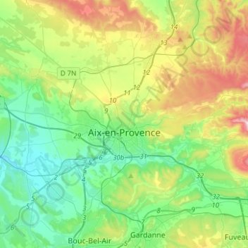
Name: Aix-en-Provence topographic map, elevation, terrain.
Average elevation: 886 ft
Minimum elevation: 299 ft
Maximum elevation: 2,231 ft

Click on the map to display elevation.
Name: Aix-en-Provence topographic map, elevation, terrain.
Average elevation: 886 ft
Minimum elevation: 299 ft
Maximum elevation: 2,231 ft