
Tam Đảo District topographic map
Interactive map
Click on the map to display elevation.
About this map
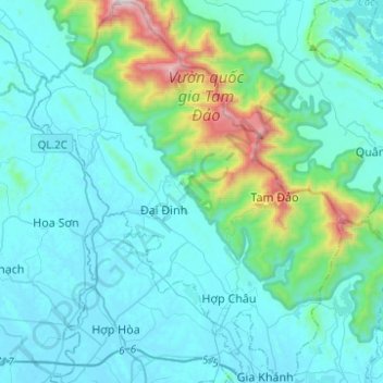
Name: Tam Đảo District topographic map, elevation, terrain.
Location: Tam Đảo District, Vinh Phuc Province, Vietnam (21.34327 105.48756 21.57384 105.68785)
Average elevation: 699 ft
Minimum elevation: 30 ft
Maximum elevation: 5,108 ft
Other topographic maps
Click on a map to view its topography, its elevation and its terrain.
Gia Khánh
Vietnam > Vinh Phuc Province > Gia Khánh
Gia Khánh, Binh Xuyen District, Vinh Phuc Province, 15000, Vietnam
Average elevation: 102 ft