
Sidon District topographic map
Interactive map
Click on the map to display elevation.
About this map
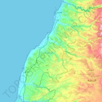
Name: Sidon District topographic map, elevation, terrain.
Location: Sidon District, South Governorate, 1600, Lebanon (33.32028 35.24415 33.58899 35.51210)
Average elevation: 531 ft
Minimum elevation: -3 ft
Maximum elevation: 2,093 ft
Other topographic maps
Click on a map to view its topography, its elevation and its terrain.
Bissariyeh
Bissariyeh, Sidon District, South Governorate, Lebanon
Average elevation: 443 ft
Tyre
Tyre, Tyre District, South Governorate, 1601, Lebanon
Average elevation: 16 ft
Jezzine
Jezzine, Jezzine District, South Governorate, 1623, Lebanon
Average elevation: 3,517 ft
Naqura
Lebanon > South Governorate > Naqura
Naqura, Borj En-Naqoura, Tyre District, South Governorate, Lebanon
Average elevation: 194 ft