
Oudesluis topographic map
Interactive map
Click on the map to display elevation.
About this map
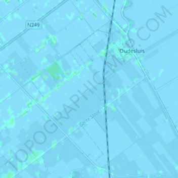
Name: Oudesluis topographic map, elevation, terrain.
Location: Oudesluis, Schagen, Noord-Holland, Nederland (52.80682 4.77224 52.84377 4.83457)
Average elevation: -3 ft
Minimum elevation: -13 ft
Maximum elevation: 10 ft
Other topographic maps
Click on a map to view its topography, its elevation and its terrain.
Sint Maarten
Nederland > Noord-Holland > Schagen > Sint Maarten
Sint Maarten, Schagen, Noord-Holland, Nederland
Average elevation: 0 ft
't Zand
Nederland > Noord-Holland > Schagen > 't Zand
't Zand, Schagen, Noord-Holland, Nederland, 1756, Nederland
Average elevation: 0 ft
Groote Keeten
Nederland > Noord-Holland > Schagen > Groote Keeten
Groote Keeten, Schagen, Noord-Holland, Nederland, 1759, Nederland
Average elevation: 0 ft
Krabbendam
Nederland > Noord-Holland > Schagen > Warmenhuizen > Krabbendam
Krabbendam, Warmenhuizen, Schagen, Noord-Holland, Nederland, 1749, Nederland
Average elevation: 0 ft