
Make a donation
Gear up for your next adventure:
As an Amazon Associate, this site earns from qualifying purchases at no extra cost to you.
Лысьва topographic map
Click on the map to display elevation.
Make a donation
Gear up for your next adventure:
As an Amazon Associate, this site earns from qualifying purchases at no extra cost to you.
About this map
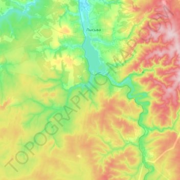
Name: Лысьва topographic map, elevation, terrain.
Average elevation: 784 ft
Minimum elevation: 459 ft
Maximum elevation: 1,263 ft
Make a donation
Gear up for your next adventure:
As an Amazon Associate, this site earns from qualifying purchases at no extra cost to you.
Other topographic maps
Click on a map to view its topography, its elevation and its terrain.
Каменный Лог
Россия > Пермский край > Лысьвенский муниципальный округ
Климат умеренно-континентальный. Среднегодовая температура воздуха равна: +1,7оС; продолжительность безморозного периода: 165 дней; средняя мощность снегового покрова: 50…
Average elevation: 673 ft