
Lac Léon topographic map
Interactive map
Click on the map to display elevation.
About this map
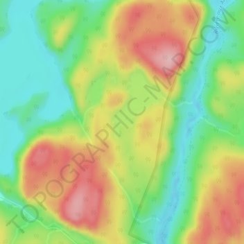
Name: Lac Léon topographic map, elevation, terrain.
Average elevation: 404 ft
Minimum elevation: 154 ft
Maximum elevation: 702 ft
Other topographic maps
Click on a map to view its topography, its elevation and its terrain.
Baie-Comeau
Canada > Québec > Manicouagan > Baie-Comeau
Baie-Comeau, Manicouagan, Côte-Nord, Québec, G4Z 1T7, Canada
Average elevation: 230 ft
Lac Frigon
Canada > Québec > Manicouagan > Baie-Comeau
Lac Frigon, Baie-Comeau, Manicouagan, Côte-Nord, Québec, Canada
Average elevation: 558 ft