
Lake Saint Clair topographic map
Interactive map
Click on the map to display elevation.
About this map
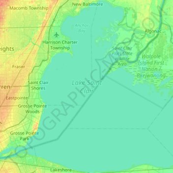
Name: Lake Saint Clair topographic map, elevation, terrain.
Location: Lake Saint Clair, Macomb County, Michigan, United States (42.29658 -82.94216 42.69047 -82.40793)
Average elevation: 581 ft
Minimum elevation: 561 ft
Maximum elevation: 653 ft
Other topographic maps
Click on a map to view its topography, its elevation and its terrain.
Fraser
United States > Michigan > Macomb County
Fraser, Macomb County, Michigan, 48026, United States
Average elevation: 617 ft
Washington Charter Township
United States > Michigan > Macomb County
Washington Charter Township, Macomb County, Michigan, 48095, United States
Average elevation: 791 ft
Forest Lake
United States > Michigan > Macomb County > Shelby Charter Township
Forest Lake, Shelby Charter Township, Macomb County, Michigan, United States
Average elevation: 663 ft
Memphis
United States > Michigan > Macomb County
Memphis, Macomb County, Michigan, United States
Average elevation: 741 ft
Clinton Charter Township
United States > Michigan > Macomb County
Clinton Charter Township, Macomb County, Michigan, United States
Average elevation: 604 ft
New Baltimore
United States > Michigan > Macomb County
New Baltimore, Macomb County, Michigan, United States
Average elevation: 584 ft
Saint Clair Shores
United States > Michigan > Macomb County
Saint Clair Shores, Macomb County, Michigan, United States
Average elevation: 587 ft
Milton
United States > Michigan > Macomb County > Chesterfield Township
Milton, Chesterfield Township, Macomb County, Michigan, 48051, United States
Average elevation: 614 ft
Chesterfield Shores
United States > Michigan > Macomb County > Chesterfield Township
Chesterfield Shores, Chesterfield Township, Macomb County, Michigan, 48047, United States
Average elevation: 584 ft
Macomb Township
United States > Michigan > Macomb County
Macomb Township, Macomb County, Michigan, United States
Average elevation: 610 ft
Mount Clemens
United States > Michigan > Macomb County
Mount Clemens, Macomb County, Michigan, 48043, United States
Average elevation: 600 ft
Romeo
United States > Michigan > Macomb County > Romeo
Romeo, Macomb County, Michigan, United States
Average elevation: 810 ft
Sterling Heights
United States > Michigan > Macomb County
Sterling Heights, Macomb County, Michigan, United States
Average elevation: 627 ft
Chesterfield Township
United States > Michigan > Macomb County
Chesterfield Township, Macomb County, Michigan, United States
Average elevation: 604 ft
Warren
United States > Michigan > Macomb County
Warren, Macomb County, Michigan, United States
Average elevation: 623 ft
Richmond Township
United States > Michigan > Macomb County
Richmond Township, Macomb County, Michigan, 48062, United States
Average elevation: 745 ft
Eastpointe
United States > Michigan > Macomb County
Eastpointe, Macomb County, Michigan, 48021, United States
Average elevation: 614 ft
Armada Township
United States > Michigan > Macomb County
Armada Township, Macomb County, Michigan, 48005, United States
Average elevation: 764 ft
Armada
United States > Michigan > Macomb County > Armada
Armada, Macomb County, Michigan, United States
Average elevation: 748 ft
Sterling Heights
United States > Michigan > Macomb County > Sterling Heights > Sterling Heights
Sterling Heights, Macomb County, Michigan, 48313-4615, United States
Average elevation: 673 ft
Roseville
United States > Michigan > Macomb County
Roseville, Macomb County, Michigan, 48066, United States
Average elevation: 614 ft
Harrison Township
United States > Michigan > Macomb County
Harrison Township, Macomb County, Michigan, United States
Average elevation: 581 ft
Shelby Charter Township
United States > Michigan > Macomb County
Shelby Charter Township, Macomb County, Michigan, United States
Average elevation: 673 ft