
New Baltimore topographic map
Click on the map to display elevation.
About this map
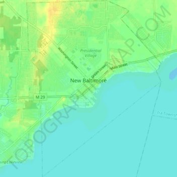
Name: New Baltimore topographic map, elevation, terrain.
Location: New Baltimore, Macomb County, Michigan, United States (42.65115 -82.76300 42.70606 -82.70597)
Average elevation: 584 ft
Minimum elevation: 561 ft
Maximum elevation: 630 ft
Macomb County trails, hiking, mountain biking, running and outdoor activities
Other topographic maps
Click on a map to view its topography, its elevation and its terrain.
Anchor Bay Shores
United States > Michigan > Macomb County > Chesterfield Township
Average elevation: 577 ft
Saint Clair Haven
United States > Michigan > Macomb County > Harrison Township
Average elevation: 574 ft
Preston Corners
United States > Michigan > Macomb County > Shelby Charter Township
Average elevation: 650 ft
Sterling Heights
United States > Michigan > Macomb County > Sterling Heights > Sterling Heights
Average elevation: 673 ft