
Klaffenbach topographic map
Interactive map
Click on the map to display elevation.
About this map
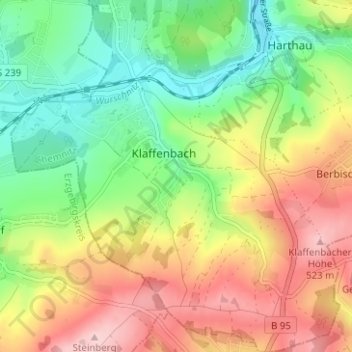
Name: Klaffenbach topographic map, elevation, terrain.
Location: Klaffenbach, Chemnitz, Saxe, Allemagne (50.74138 12.87952 50.78100 12.93870)
Average elevation: 1,358 ft
Minimum elevation: 1,050 ft
Maximum elevation: 1,745 ft
Other topographic maps
Click on a map to view its topography, its elevation and its terrain.
Sonnenberg
Sonnenberg, Chemnitz, Saxe, 09130, Allemagne
Average elevation: 1,060 ft