
Spire topographic map
Interactive map
Click on the map to display elevation.
About this map
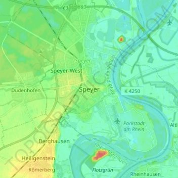
Name: Spire topographic map, elevation, terrain.
Location: Spire, Speyer, Rhénanie-Palatinat, 67346, Allemagne (49.27656 8.39362 49.35656 8.47362)
Average elevation: 331 ft
Minimum elevation: 292 ft
Maximum elevation: 440 ft
Other topographic maps
Click on a map to view its topography, its elevation and its terrain.
Spire
Allemagne > Rhénanie-Palatinat > Spire
Spire, Rhénanie-Palatinat, Allemagne
Average elevation: 328 ft