
Okupe Lagoon topographic map
Interactive map
Click on the map to display elevation.
About this map
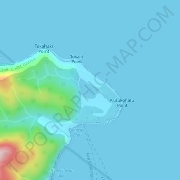
Name: Okupe Lagoon topographic map, elevation, terrain.
Average elevation: 85 ft
Minimum elevation: 0 ft
Maximum elevation: 919 ft
Other topographic maps
Click on a map to view its topography, its elevation and its terrain.
Mangaroa River
New Zealand > Wellington > Upper Hutt
Mangaroa River, Upper Hutt, Upper Hutt City, Wellington, 5371, New Zealand
Average elevation: 928 ft
Te Haukaretu Park
New Zealand > Wellington > Upper Hutt
Te Haukaretu Park, Maoribank, Upper Hutt, Upper Hutt City, Wellington, New Zealand
Average elevation: 371 ft
Eastern Hutt River
New Zealand > Wellington > Upper Hutt
Eastern Hutt River, Upper Hutt, Upper Hutt City, Wellington, New Zealand
Average elevation: 2,680 ft
Climie
New Zealand > Wellington > Upper Hutt
Climie, Upper Hutt, Upper Hutt City, Wellington, 5371, New Zealand
Average elevation: 1,998 ft
Akatarawa River
New Zealand > Wellington > Upper Hutt
Akatarawa River, Upper Hutt, Upper Hutt City, Wellington, 6007, New Zealand
Average elevation: 1,404 ft
Whakatikei River
New Zealand > Wellington > Upper Hutt
Whakatikei River, Upper Hutt, Upper Hutt City, Wellington, 5018, New Zealand
Average elevation: 1,037 ft
Pakuratahi River
New Zealand > Wellington > Upper Hutt
Pakuratahi River, Upper Hutt, Upper Hutt City, Wellington, New Zealand
Average elevation: 1,158 ft