
Altenstadt topographic map
Interactive map
Click on the map to display elevation.
About this map
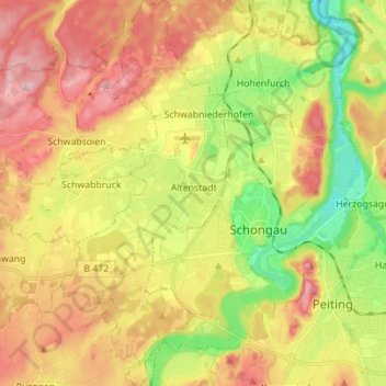
Name: Altenstadt topographic map, elevation, terrain.
Average elevation: 2,421 ft
Minimum elevation: 2,119 ft
Maximum elevation: 2,717 ft
Other topographic maps
Click on a map to view its topography, its elevation and its terrain.
Hapberg
Duitsland > Beieren > Landkreis Weilheim-Schongau > Bernried am Starnberger See
Hapberg, Bernried am Starnberger See, Landkreis Weilheim-Schongau, Beieren, 82347, Duitsland
Average elevation: 2,001 ft
Böbing
Duitsland > Beieren > Landkreis Weilheim-Schongau
Böbing, Rottenbuch (VGem), Landkreis Weilheim-Schongau, Beieren, 82389, Duitsland
Average elevation: 2,510 ft