
Resende topographic map
Click on the map to display elevation.
About this map
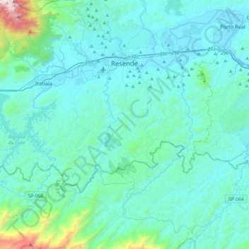
Name: Resende topographic map, elevation, terrain.
Average elevation: 1,932 ft
Minimum elevation: 1,253 ft
Maximum elevation: 8,061 ft
Other topographic maps
Click on a map to view its topography, its elevation and its terrain.
Sugarloaf
Brazil > Rio de Janeiro > Região Metropolitana do Rio de Janeiro > Rio de Janeiro
Average elevation: 56 ft
Corcovado
Brazil > Rio de Janeiro > Região Metropolitana do Rio de Janeiro > Rio de Janeiro
Average elevation: 725 ft
Quinta da Boa Vista
Brazil > Rio de Janeiro > Região Metropolitana do Rio de Janeiro > Rio de Janeiro
Average elevation: 62 ft
Praça Heitor Bastos Tigre
Brazil > Rio de Janeiro > Região Metropolitana do Rio de Janeiro > Rio de Janeiro
Average elevation: 23 ft
Vale das Pedrinhas
Brazil > Rio de Janeiro > Região Metropolitana do Rio de Janeiro > Guapimirim
Average elevation: 26 ft
Morro da Babilônia
Brazil > Rio de Janeiro > Região Metropolitana do Rio de Janeiro > Rio de Janeiro
Average elevation: 95 ft
Morro da Babilônia
Brazil > Rio de Janeiro > Região Metropolitana do Rio de Janeiro > Rio de Janeiro
Average elevation: 95 ft
Morro da Babilônia
Brazil > Rio de Janeiro > Região Metropolitana do Rio de Janeiro > Rio de Janeiro
Average elevation: 95 ft
Manuel de Morais
Brazil > Rio de Janeiro > Trajano de Moraes > Visconde de Imbé
Average elevation: 1,188 ft