
Igrexafeita topographic map
Interactive map
Click on the map to display elevation.
About this map
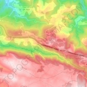
Name: Igrexafeita topographic map, elevation, terrain.
Location: Igrexafeita, San Sadurniño, Ferrol, La Coruña, Galicia, España (43.47288 -8.04425 43.51759 -7.96776)
Average elevation: 1,145 ft
Minimum elevation: 223 ft
Maximum elevation: 1,745 ft
Other topographic maps
Click on a map to view its topography, its elevation and its terrain.
Bouzamaior
España > Galicia > Ferrol > San Sadurniño
Bouzamaior, Igrexafeita, San Sadurniño, Ferrol, La Coruña, Galicia, 15324, España
Average elevation: 1,181 ft