
Urdesa topographic map
Interactive map
Click on the map to display elevation.
About this map
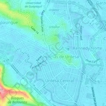
Name: Urdesa topographic map, elevation, terrain.
Location: Urdesa, Tarqui, Guayaquil, Guayas, Ecuador (-2.17813 -79.91972 -2.14710 -79.90109)
Average elevation: 69 ft
Minimum elevation: -20 ft
Maximum elevation: 643 ft
Other topographic maps
Click on a map to view its topography, its elevation and its terrain.
Puerto Hondo
Ecuador > Guayas > Guayaquil > Guayaquil > Puerto Hondo
Puerto Hondo, Guayaquil, Guayas, 090901, Ecuador
Average elevation: 171 ft