
Make a donation
Gear up for your next adventure:
As an Amazon Associate, this site earns from qualifying purchases at no extra cost to you.
Bendigo topographic map
Click on the map to display elevation.
Make a donation
Gear up for your next adventure:
As an Amazon Associate, this site earns from qualifying purchases at no extra cost to you.
About this map
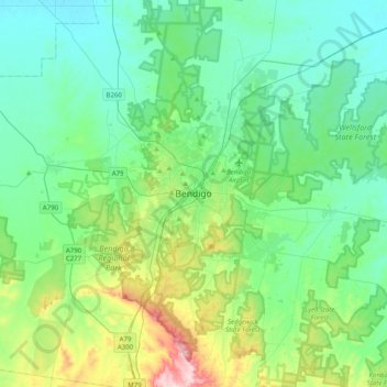
Name: Bendigo topographic map, elevation, terrain.
Average elevation: 732 ft
Minimum elevation: 456 ft
Maximum elevation: 1,755 ft
Make a donation
Gear up for your next adventure:
As an Amazon Associate, this site earns from qualifying purchases at no extra cost to you.
Other topographic maps
Click on a map to view its topography, its elevation and its terrain.
Bairnsdale
A comprehensive geological survey of Victoria's Great Dividing Range reveals a distinct north-south alignment in its bedrock, a vestige of the bygone epochs of plate tectonics. This enduring geological framework, coupled with ongoing tectonic activity, contributes to the dynamic topography witnessed in the…
Average elevation: 82 ft
Make a donation
Gear up for your next adventure:
As an Amazon Associate, this site earns from qualifying purchases at no extra cost to you.
Make a donation
Gear up for your next adventure:
As an Amazon Associate, this site earns from qualifying purchases at no extra cost to you.
Make a donation
Gear up for your next adventure:
As an Amazon Associate, this site earns from qualifying purchases at no extra cost to you.
Make a donation
Gear up for your next adventure:
As an Amazon Associate, this site earns from qualifying purchases at no extra cost to you.
Omeo
There are bus routes from Bright and Bairnsdale. The Bairnsdale bus runs weekdays, once both directions, and the Bright bus (Alps Link) timetable is less frequent in Summer and runs additional services during the ski season. Alps Link is the highest altitude public bus in Australia. The town sits at the…
Average elevation: 2,825 ft