
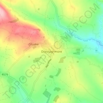
Donoughmore topographic map
Interactive map
Click on the map to display elevation.
About this map
Name: Donoughmore topographic map, elevation, terrain.
Average elevation: 600 ft
Minimum elevation: 390 ft
Maximum elevation: 892 ft
Other topographic maps
Click on a map to view its topography, its elevation and its terrain.
Kilnamartery
Ireland > County Cork > Municipal District of Macroom
Kilnamartery, Municipal District of Macroom, County Cork, Munster, Ireland
Average elevation: 387 ft
Iniscarra Dam View
Ireland > County Cork > Municipal District of Macroom
Iniscarra Dam View, L5228, Ovens, Municipal District of Macroom, County Cork, Munster, P31 TX39, Ireland
Average elevation: 272 ft
Monallig
Ireland > County Cork > Municipal District of Macroom
Monallig, Cannaway ED, Municipal District of Macroom, County Cork, Munster, Ireland
Average elevation: 295 ft
Drominahilla
Ireland > County Cork > Municipal District of Macroom
Drominahilla, Drishane, Municipal District of Macroom, County Cork, Munster, Ireland
Average elevation: 417 ft
Macroom
Ireland > County Cork > Municipal District of Macroom
Macroom, Municipal District of Macroom, County Cork, Munster, Ireland
Average elevation: 689 ft
Loughane East
Ireland > County Cork > Municipal District of Macroom
Loughane East, Matehy, Municipal District of Macroom, County Cork, Munster, Ireland
Average elevation: 322 ft