Geolocate

Paisley topographic map

Click on the map to display elevation.

About this map

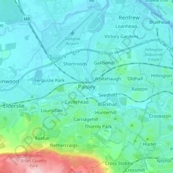
Name: Paisley topographic map, elevation, terrain.

Location: Paisley, Renfrewshire, Scotland, PA1 1DG, United Kingdom (55.80558 -4.46396 55.88558 -4.38396)

Average elevation: 108 ft

Minimum elevation: -13 ft

Maximum elevation: 751 ft

Other topographic maps

Click on a map to view its topography, its elevation and its terrain.

River Cart

United Kingdom > Scotland > Renfrewshire > Renfrew

Average elevation: 20 ft

Gear up for your next adventure:

🪶Fire Starter Kit - Reliable fire starter for survival and camping
🌐World Map Poster - Decorative world maps with topographic info
📡Handheld GPS Device - Reliable handheld GPS for outdoor navigation
🧦Hiking Socks - Comfortable socks to prevent blisters on long hikes
Backpacking Tents - Weight-optimized shelters for multi-day topographic surveys

As an Amazon Associate, this site earns from qualifying purchases at no extra cost to you.